Rohtas, Bihar: The Land of Sher Shah’s Legacy
Rohtas, with its headquarters in Sasaram, is a historically rich district in Patna Division, celebrated for its association with Sher Shah Suri, the 16th-century ruler who built the iconic Sher Shah Suri Tomb and Rohtasgarh Fort. Nestled along the Son and Kali rivers, Rohtas is an agricultural and industrial hub, known for cement production and scenic sites like Indrapuri Dam. Bordering Jharkhand and Uttar Pradesh, the district blends Mughal heritage with modern growth, governed by the Sasaram Municipal Corporation.
Basic Details of Rohtas District:
- Location: Rohtas district is situated in southwestern Bihar, between 24.57°–25.25°N latitude and 83.67°–84.50°E longitude, at an average elevation of 110 meters (360 feet). It lies in the Gangetic plains, with hilly terrain in the Kaimur Range.
- Administrative Status: Rohtas is the headquarters of Rohtas district and part of the Patna division, which includes Patna, Buxar, Bhojpur, Kaimur, and Nalanda. Sasaram, the district headquarters, is a municipal corporation and a major urban and historical center.
- Population: As provided, the district’s population is 29,59,918 (2011 census), with Sasaram city at ~147,408 (urban). The density is 763 persons/km², relatively low due to its large area and hilly regions.
- Area: The district spans 3,851 sq. km, one of Bihar’s larger districts, encompassing urban, rural, agricultural, and forested areas.
- Nickname: Rohtas is known as the “Land of Sher Shah Suri” for its Mughal-era heritage and the “Gateway to Jharkhand” for its southern border.
1. Formation and History
- Formation:
- Rohtas district was carved out from the erstwhile Shahabad district in 1972 to enhance administrative efficiency and promote development in southwestern Bihar. The bifurcation created Rohtas and Kaimur districts from Shahabad’s vast territory.
- The district’s name derives from the Rohtasgarh Fort, a historical stronghold named after Prince Rohitashva, son of King Harishchandra, in ancient lore.
- Historical Significance:
- Ancient Period:
- Rohtas was part of the Magadha empire, significant in Buddhist and Jain traditions. The Kaimur Hills hosted ancient rock-cut caves and settlements.
- The region was under the Maurya and Gupta empires, with evidence of trade routes connecting the Gangetic plains to central India.
- Medieval Period:
- The Rohtasgarh Fort, built in the 7th century and expanded by the Kharwar dynasty, became a strategic stronghold. It was captured by Sher Shah Suri in 1539, who fortified it as a military base.
- Sher Shah Suri (1540–1545), the Afghan ruler who briefly ousted the Mughals, was born in Sasaram. His tomb, a masterpiece of Indo-Islamic architecture, is a UNESCO-nominated site.
- The region saw Mughal and Rajput rule, with the fort changing hands multiple times.
- Colonial Period:
- Under British rule, Rohtas was part of Shahabad district, known for rice and indigo production. The Son Canal System, initiated in the 19th century, transformed agriculture.
- The region participated in the 1857 Rebellion, with local zamindars resisting British control.
- Modern Era:
- Post-independence, Rohtas developed as an industrial and agricultural hub, with cement and sugar industries flourishing.
- The district’s historical sites, like Rohtasgarh Fort and Sher Shah’s tomb, attract tourists, while the Indrapuri Dam supports irrigation and tourism.
- Rohtas’s proximity to Jharkhand and Uttar Pradesh fosters trade and cultural exchange.
- Ancient Period:
2. Administrative Structure
- Rohtas District
- Rohtas District, one of Bihar’s 38 districts, spans 3,851 sq km and is part of Patna Division, alongside Patna, Nalanda, Bhojpur, Buxar, and Kaimur. It comprises 3 sub-divisions (Sasaram, Dehri, Bikramganj), 19 blocks, 245 panchayats, and 2,494 villages. A District Magistrate oversees administration, supported by SDMs and BDOs. In 2006, it was listed among India’s 250 most backward districts, receiving Backward Regions Grant Fund support.
- Urban Governance
- The Sasaram Municipal Corporation, established in 2018, governs 166,745 residents (2011) across 40 wards. Led by a Mayor and CEO, it manages urban planning, sanitation, and infrastructure, funded by taxes and grants. Reservations include 50% seats for women and 20% for backward classes, per the Bihar Municipal Act of 2007.
3. Location and Geography
- Geographical Boundaries:
- North: Buxar and Bhojpur districts.
- East: Arwal and Aurangabad districts.
- South: Jharkhand (Palamu and Garhwa districts).
- West: Kaimur district and Uttar Pradesh (Chandauli and Sonbhadra districts).
- Rohtas’s location, 150 km southwest of Patna and 50 km from Dehri-on-Son, makes it a key link for trade and tourism in southwestern Bihar.
- Rivers:
- Son: A major river flowing from Madhya Pradesh, supporting irrigation via the Son Canal System and tourism at Indrapuri Dam.
- Kali: A smaller river aiding agriculture in rural areas.
- Other streams, like Durgawati, contribute to the district’s fertile plains.
- Topography and Climate:
- Spanning 3,851 sq. km, Rohtas features flat Gangetic plains in the north and the Kaimur Plateau (part of the Vindhyan Range) in the south, with elevations up to 500 meters. Forests cover ~20% of the area, including the Kaimur Wildlife Sanctuary.
- Climate: Humid subtropical (Cwa).
- Summer (March–June): Hot, 28–45°C.
- Monsoon (July–September): Moderate rainfall (~1,000 mm annually), with occasional flooding in Son river areas.
- Winter (November–February): Cool, 5–25°C, ideal for tourism and pilgrimage.
- Seismic Risk: Located in Seismic Zone III (moderate risk).
4. Industries and Agriculture
Rohtas’s economy is driven by agriculture, industry, and tourism, leveraging its fertile plains and mineral-rich Kaimur hills.
- Industries:
- Cement Factory: Utilizes limestone from Kaimur hills, with major plants in Banjari and Dalmianagar.
- Vegetable Oil Mill: Processes oilseeds like mustard and soybean, supporting local markets.
- Paper Factory: Located in Dalmianagar, processes agricultural byproducts and timber.
- Sugar Industry: Mills in Sasaram and Dehri process sugarcane, though less prominent than in north Bihar.
- Other Industries:
- Agro-processing for rice and wheat.
- Stone quarrying and crushing, leveraging Kaimur’s mineral resources.
- Small-scale textiles and handicrafts, including pottery and woodwork.
- Recent Developments:
- The Bihar Industrial Area Development Authority (BIADA) promotes cement and agro-based industries in Sasaram, with plans for a Mineral-Based Industrial Cluster in Dalmianagar.
- Revival of the Dalmianagar Industrial Complex, historically a hub for cement and paper, to boost employment.
- Agriculture:
- Fertile plains support:
- Paddy: The primary crop, widely cultivated due to Son Canal irrigation.
- Wheat: A major rabi crop, supporting food security.
- Other Crops: Maize, lentils, sugarcane, and vegetables.
- The Son Canal System, one of Asia’s largest, irrigates ~70% of farmland, enhancing productivity.
- Agricultural Initiatives: The National Horticulture Mission supports vegetable and fruit farming, with cold storage facilities in Sasaram and Dehri.
- Fertile plains support:
5. Tourism
Rohtas is a historical and spiritual destination, known for its forts, temples, and natural beauty. The best time to visit is October to March.
- Key Tourist Places:
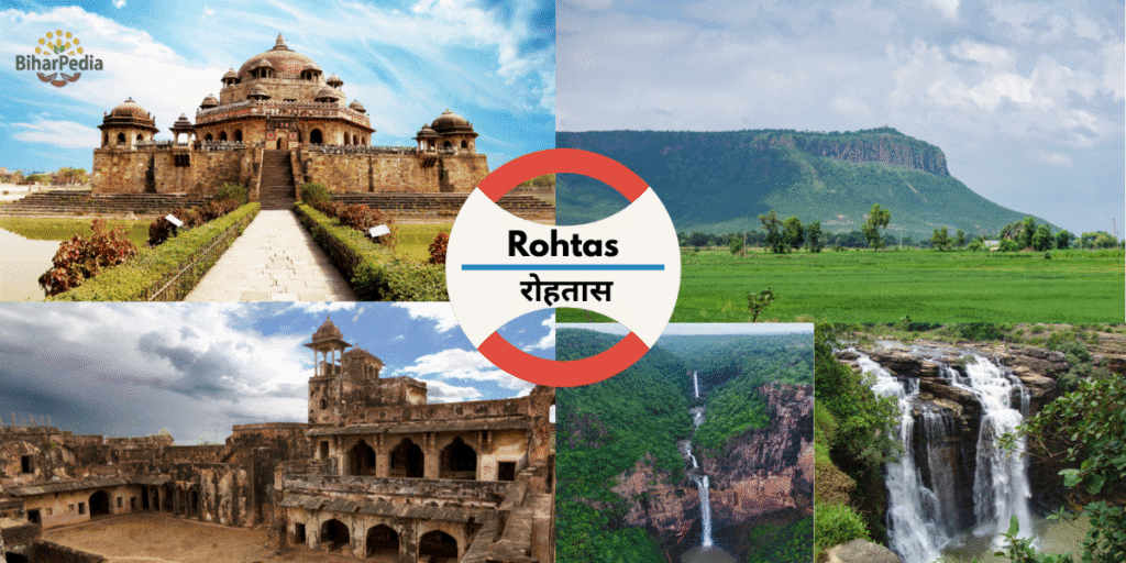
- Sher Shah Suri Tomb (Sasaram): A UNESCO-nominated mausoleum (1545) of Sher Shah Suri, an architectural marvel with a dome and lake setting, reflecting Indo-Islamic design.
- Rohtasgarh Fort (Rohtas): A 7th-century hill fort, expanded by Sher Shah Suri, perched on Kaimur hills. It features palaces, temples, and gates, offering panoramic views.
- Indrapuri Dam (Dehri): One of India’s oldest dams on the Son river, part of the Son Canal System, popular for boating and picnics.
- Hills of Kaimur: Part of the Kaimur Wildlife Sanctuary, home to leopards, deer, and birds, ideal for trekking and nature tours.
- Dhuwa Kund (near Sasaram): A scenic waterfall on the Durgawati river, a spiritual and picnic spot, especially during monsoons.
- Maa Tara Chandi Temple (Sasaram): A revered Shakti Peeth, attracting devotees during Navratri and Chhath Puja.
- Pilot Baba Temple (Dehri): A modern temple dedicated to Pilot Baba, a spiritual guru, popular among locals.
- Gupta Dham (Chenari): A cave temple complex in the Kaimur hills, linked to Gupta-era rock art and Hindu worship.
- Manjhar Kund (near Sasaram): A twin waterfall and pilgrimage site, known for its serene setting and mythological significance.
- Additional Attractions:
- Chandika Temple (Tilothu): A Durga temple, significant during Durga Puja.
- Tomb of Hasan Khan Sur (Sasaram): Sher Shah’s father’s mausoleum, a smaller but architecturally similar site to Sher Shah’s tomb.
- Kaimur Wildlife Sanctuary: Spans 1,500 sq. km, offering safaris, birdwatching, and views of Telhar Kund waterfall.
- Dehri-on-Son: A historical town with colonial-era buildings and the Son Canal headworks.
- Mundeshwari Temple (Kaimur, near Rohtas border): One of India’s oldest functional Hindu temples (4th century), often visited from Rohtas.
- Sasaram Railway Station: A heritage structure with Mughal-era architectural elements.
- Dalmianagar Industrial Ruins: Remnants of a 20th-century industrial township, attracting history enthusiasts.
- Nearby Attractions:
- Kaimur (50 km): Mundeshwari Temple, Baidyanath Dham.
- Buxar (70 km): Buxar Fort, Battle of Buxar site.
- Patna (150 km): Patna Museum, Golghar.
- Varanasi, Uttar Pradesh (120 km): Kashi Vishwanath Temple, Sarnath.
- Tourism Support: The Sasaram Municipal Corporation, under the Bihar Municipal Act of 2007, promotes tourism through urban beautification, maintenance of sites like Sher Shah’s tomb, and cultural events like Rohtas Mahotsav, per the Twelfth Schedule (e.g., cultural promotion and urban planning).
6. Important Statistical Data
- Area: 3,851 sq. km, one of Bihar’s larger districts, supporting agriculture, industry, and forests.
- Headquarters: Sasaram, a historical and commercial hub.
- Population: 29,59,918 (2011), comparable to countries like Yemen or U.S. states like Mississippi.
- Urban population: ~15% (Sasaram: 147,408).
- Growth rate (2001–2011): 20.96%.
- Density: 763 persons/km², low due to hilly and forested areas.
- Literacy Rate: 73.37% (male: 81.67%, female: 64.38%), above Bihar’s average but with a gender gap.
- Sex Ratio: 918 females/1,000 males, slightly below national norms.
Additional Data:
- Scheduled Castes: 18.97%.
- Scheduled Tribes: 1.12%.
- Languages: Hindi, Bhojpuri, Urdu.
- Urban Bodies: Sasaram Municipal Corporation (40 wards, with 50% reservations for women, SC/ST, OBC) and nagar panchayats like Dehri, Nokha, and Bikramganj, per the Bihar Municipal Act of 2007.
7. Culture and Society
- Language: Hindi and Bhojpuri dominate, with Urdu spoken in Sasaram’s Muslim communities. The district’s cultural narrative includes Mughal history and folk traditions.
- Art and Craft:
- Pottery: Traditional clay items, popular during Chhath Puja.
- Stone Carving: Reflects Kaimur’s mineral wealth, with artifacts sold in Sasaram markets.
- Handicrafts, including woodwork and bamboo, inspired by Mughal aesthetics.
- Festivals:
- Chhath Puja: Widely celebrated along Son river ghats, a cultural hallmark.
- Navratri: Draws devotees to Maa Tara Chandi and Chandika temples.
- Muharram: Significant in Sasaram, reflecting Sher Shah’s Afghan legacy.
- Diwali, Holi, Eid, Makar Sankranti.
- Cuisine:
- Bihari staples: litti-chokha, sattu paratha, khichdi, dalpuri.
- Sweets: thekua, khaja, balushahi.
- Local specialties include rice-based dishes, reflecting paddy cultivation.
- Social Challenges:
- Gender disparities in literacy (female: 64.38%) and rural poverty.
- Occasional flooding in Son river areas affects agriculture.
- The Sasaram Municipal Corporation addresses slum improvement, public health, and education, per the Twelfth Schedule.
8. Economy and Infrastructure
- Economic Role:
- Rohtas’s economy is anchored by agriculture, cement, and tourism, with Sasaram and Dehri as commercial hubs.
- Markets like Sasaram Bazaar and Dehri Market trade in rice, cement, and handicrafts.
- Proximity to Jharkhand and Uttar Pradesh supports mineral and agricultural trade.
- Infrastructure:
- Transportation:
- Rail: Sasaram and Dehri-on-Son are major stations on the Delhi-Howrah line, connecting to Patna (3 hours), Delhi (12 hours), and Kolkata (8 hours).
- Road: On NH-19 (Grand Trunk Road), NH-119, and NH-120, linking to Patna (150 km), Varanasi (120 km), and Jharkhand’s Ranchi (200 km). Buses, taxis, and e-rickshaws are common.
- Air: No local airport; nearest is Gaya International Airport (100 km) or Patna’s Jay Prakash Narayan International Airport (150 km).
- Local Transport: Cycle-rickshaws and shared autos in Sasaram and rural areas.
- Digital Infrastructure: The district website (http://rohtas.nic.in) offers e-governance services like tenders, voter registration, and tourism information.
- Healthcare: Sadar Hospital Sasaram, Narayan Medical College and Hospital, and private clinics. Patna’s facilities are accessible for advanced care.
- Urban Development: The Sasaram Municipal Corporation manages urban planning, waste management, and infrastructure, funded by taxes and grants. Sasaram is part of the AMRUT scheme, with projects like water supply and heritage site preservation.
- Transportation:
9. Education
- Universities:
- Narayan Medical College and Hospital, Sasaram: Offers medical education and healthcare training.
- S.S. College, Sasaram: A prominent institution for arts, science, and commerce.
- Other Institutions: S.P. Jain College, Dehri, A.S. College, Bikramganj, and schools like DAV Public School, Sasaram.
- Vocational Training: Centers for cement industry skills and agricultural techniques, supporting rural youth.
10. Recent Developments
- Tourism Infrastructure:
- Upgrades to Rohtasgarh Fort and Sher Shah’s tomb, with better lighting and visitor centers, ahead of 2025 tourism season.
- Promotion of Rohtas as part of the Mughal Heritage Circuit with Sasaram and Delhi.
- Industrial Growth:
- Mineral-Based Industrial Cluster planned in Dalmianagar to leverage limestone and cement.
- Revival of Dalmianagar’s paper and cement units, supported by BIADA.
- Infrastructure:
- Son Canal Modernization: Enhances irrigation efficiency.
- AMRUT Projects: Include smart drainage and Son riverfront beautification in Sasaram.
- Environmental Efforts:
- Conservation programs in Kaimur Wildlife Sanctuary to protect biodiversity.
- Afforestation in Kaimur hills to combat soil erosion.
11. Challenges
- Socioeconomic Issues: Gender disparities in literacy (female: 64.38%) and rural poverty, particularly in hilly areas.
- Flooding: Son river causes occasional floods, affecting agriculture.
- Industrial Decline: Dalmianagar’s historical industries need revival to boost employment.
- Tourism Infrastructure: Remote sites like Rohtasgarh Fort need better road connectivity, addressed by the Municipal Corporation.
12. Practical Information for Visitors
- Best Time to Visit: October–March (5–25°C), ideal for fort visits and trekking.
- Languages: Hindi, Bhojpuri, Urdu; English understood in Sasaram.
- Shopping: Stone carvings, rice products, and handicrafts at Sasaram Bazaar.
- Cuisine: Litti-chokha, thekua, rice dishes at eateries like Rohtas Bhoj.
- Accommodation: Hotel Vaibhav, Sasaram, Son View Guest House, Dehri, budget lodges in Bikramganj.
- Helplines: Police (100), ambulance (108), district administration ([email protected]).
- Tourist Support: Bihar Tourism office (0612-2225411) or Sasaram Municipal Corporation.