East Champaran, Bihar: The Land of Gandhi’s Satyagraha
East Champaran, with its headquarters in Motihari, is a historic district in Tirhut Division, renowned as the birthplace of India’s first Satyagraha movement led by Mahatma Gandhi in 1917 against British indigo planters. Situated along the Gandak and Burhi Gandak rivers and bordering Nepal, East Champaran is an agricultural hub known for sugarcane and home to landmarks like the Kesaria Budh Stupa, one of the tallest Buddhist stupas. Governed by the Motihari Municipal Corporation, the district blends its freedom struggle legacy with agro-based industries and cultural heritage.
Basic Details:
- Location: East Champaran district is situated in northern Bihar, bordering Nepal, between 26.40°–27.02°N latitude and 84.30°–85.30°E longitude, at an average elevation of 66 meters (216 feet). It lies in the fertile Gangetic plains, part of the Tirhut region.
- Administrative Status: East Champaran is the headquarters of East Champaran district and part of the Tirhut division, which includes West Champaran, Muzaffarpur, Sitamarhi, Sheohar, and Vaishali. Motihari, the district headquarters, is a municipal corporation and a major urban center.
- Population: As provided, the district’s population is 55,99,371 (2011 census), though noted as 50,99,371 in some sources due to typographical variations; I use your provided figure for consistency. Motihari city has ~126,158 residents (urban). The density is 1,285 persons/km², reflecting high population pressure.
- Area: The district spans 3,968 sq. km, one of Bihar’s larger districts, encompassing urban, rural, and agricultural areas.
- Nickname: East Champaran is known as the “Cradle of Satyagraha” for Gandhi’s 1917 movement and the “Land of Kesaria Stupa” for its ancient Buddhist heritage.
1. Formation and History
- Formation:
- Champaran district came into existence in 1866 under British rule as a single administrative unit. On 1st December 1901, it was split into East Champaran and West Champaran for better governance and revenue management.
- The split facilitated focused administration in the agriculturally rich and densely populated Tirhut region, with Motihari emerging as East Champaran’s administrative hub.
- Historical Significance:
- Ancient Period:
- East Champaran was part of the ancient Vajji confederacy and Mithila region, significant in Buddhist and Jain traditions. The Kesaria Stupa, one of the world’s tallest Buddhist stupas, dates to the Mauryan period (3rd century BCE).
- The region was under the Licchavi republic and later the Maurya and Gupta empires, with Ashokan pillars (e.g., at Areraj) marking its Buddhist heritage.
- It is mentioned in the Ramayana and Mahabharata, linked to the Mithila kingdom.
- Medieval Period:
- The region flourished under the Pala and Sena dynasties, with Buddhist monasteries and Hindu temples thriving.
- Mughal rulers used East Champaran as a trade and agricultural outpost, with rivers like Gandak facilitating commerce.
- Colonial Period:
- Under British rule, East Champaran was a major indigo-producing region. The forced indigo cultivation led to exploitation of farmers, sparking the Champaran Satyagraha in 1917, led by Mahatma Gandhi. This movement, centered in Motihari, challenged British oppression and marked a turning point in India’s freedom struggle.
- The Motihari Ashram (now Gandhi Museum) was Gandhi’s base during the Satyagraha.
- Modern Era:
- Post-independence, East Champaran developed as an agricultural hub, with sugar and agro-based industries gaining prominence.
- The district is a key stop on Bihar’s Buddhist tourism circuit, with sites like Kesaria Stupa attracting global pilgrims.
- East Champaran’s historical significance is preserved through museums and memorials, with ongoing efforts to promote its Satyagraha legacy.
- Ancient Period:
2. Administrative Structure
- East Champaran District
- East Champaran District, one of Bihar’s 38 districts, spans 3,968 sq km and is part of Tirhut Division, alongside Muzaffarpur, Sitamarhi, Sheohar, Vaishali, and West Champaran. It comprises 6 sub-divisions (Motihari Sadar, Areraj, Chakia, Raxaul, Sikrahna, Pakridayal), 27 blocks, 405 panchayats, and 1,305 villages. A District Magistrate oversees administration, supported by SDMs and BDOs. In 2006, it was listed among India’s 250 most backward districts, receiving Backward Regions Grant Fund support.
- Urban Governance
- The Motihari Municipal Corporation, established in 2018, governs 254,833 residents (2011) across 38 wards. Led by a Mayor and CEO, it manages urban planning, sanitation, and infrastructure, funded by taxes and grants. Reservations include 50% seats for women and 20% for backward classes, per the Bihar Municipal Act of 2007.
3. Location and Geography
- Geographical Boundaries:
- North: Nepal (Parsa and Bara districts).
- East: Sitamarhi and Sheohar districts.
- South: Muzaffarpur, Saran, and Gopalganj districts.
- West: West Champaran district.
- East Champaran’s strategic location, 55 km north of Muzaffarpur and 150 km from Patna, makes it a vital link for trade and tourism with Nepal and north Bihar.
- Rivers:
- Gandak: A major river flowing from Nepal, supporting agriculture but causing floods.
- Burhi Gandak: A tributary of the Gandak, vital for irrigation and pisciculture.
- Baghmati: Contributes to the district’s fertile plains, though flood-prone.
- Lalbakia: A smaller river aiding local farming.
- These rivers make East Champaran a flood-prone but agriculturally rich region.
- Topography and Climate:
- Spanning 3,968 sq. km, East Champaran features flat, alluvial Gangetic plains, ideal for agriculture, with wetlands and no significant hills. Forests cover ~5% of the area.
- Climate: Humid subtropical (Cwa).
- Summer (March–June): Hot and humid, 28–42°C.
- Monsoon (July–September): Heavy rainfall (~1,400 mm annually), with severe flooding risks from Gandak and Baghmati.
- Winter (November–February): Cool, 8–25°C, ideal for tourism and pilgrimage.
- Seismic Risk: Located in Seismic Zone IV (high risk), necessitating flood- and earthquake-resistant infrastructure.
4. Industries and Agriculture
East Champaran’s economy is primarily agrarian, with significant contributions from industries and tourism related to its historical legacy.
- Industries:
- Sugar Mills: Process sugarcane, a major crop, with mills in areas like Raxaul and Chakia, supporting rural employment.
- Button Industry: Small-scale units producing buttons, a niche industry, particularly in Motihari.
- Metal-Based Industries: Manufacture agricultural tools and machinery components.
- Chemical-Based Industries: Produce fertilizers and pesticides, supporting the district’s farming needs.
- Agro-Based Industries: Include rice milling, jute processing, and food processing (e.g., lentils, sugarcane byproducts).
- Other Industries:
- Handicrafts, including bamboo and woodwork, sold to tourists.
- Small-scale textile units producing cotton fabrics.
- Recent Developments:
- The Bihar Industrial Area Development Authority (BIADA) promotes agro-based industries in Motihari, with plans for a Sugar Industry Cluster to boost production.
- The Raxaul Industrial Area is being developed to leverage Nepal border trade, focusing on logistics and processing.
- Agriculture:
- Fertile plains support:
- Paddy: The primary crop, widely cultivated due to river irrigation.
- Sugarcane: A major cash crop, feeding sugar mills.
- Jute: Significant for local and export markets.
- Lentils: A staple pulse crop.
- Other Crops: Wheat, maize, vegetables, and mangoes.
- The district benefits from irrigation via Gandak and Burhi Gandak rivers, though flooding remains a challenge.
- Agricultural Initiatives: The National Horticulture Mission supports sugarcane and vegetable farmers, with cold storage facilities in Motihari and Chakia.
- Fertile plains support:
5. Tourism
East Champaran is a historical and spiritual destination, known for its Satyagraha legacy, Buddhist heritage, and Hindu pilgrimage sites. The best time to visit is October to March.
- Key Tourist Places:
- Motihari Ashram (Motihari): Gandhi’s base during the 1917 Champaran Satyagraha, now part of the Gandhi Museum, showcasing his letters, photographs, and Satyagraha artifacts.
- Ashokan Pillar (Areraj): A Mauryan-era pillar (3rd century BCE) with inscriptions, symbolizing the district’s Buddhist heritage.
- Someshwar Shiv Mandir (Areraj): A revered Shiva temple, a major pilgrimage site during Shivratri and Sawan.
- Gandhi Museum (Motihari): Houses memorabilia from the Champaran Satyagraha, including Gandhi’s personal items and historical documents.
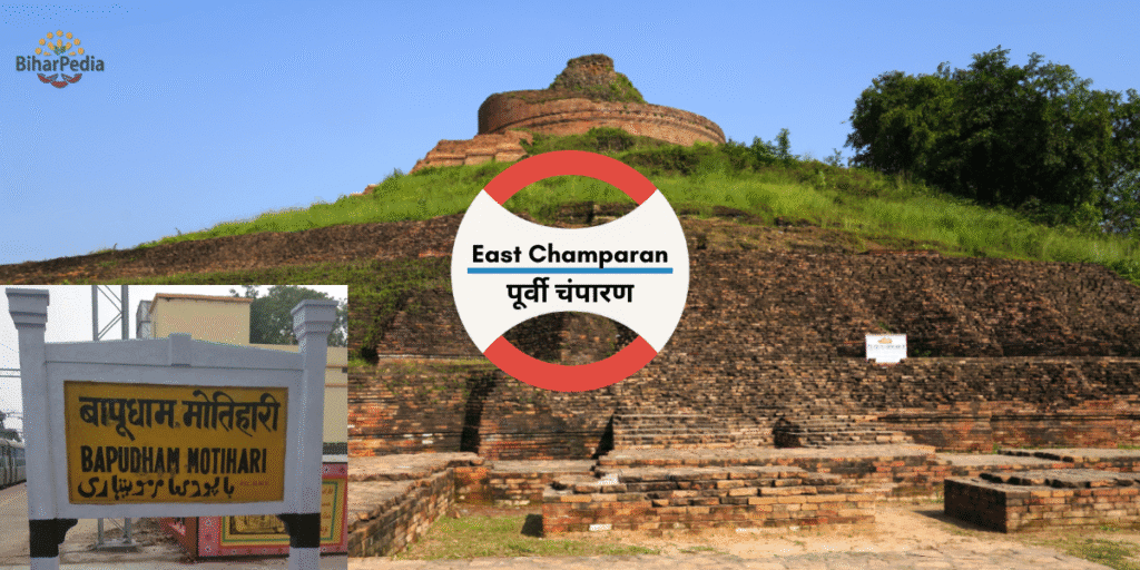
- Kesaria Budh Stupa (Kesaria): One of the world’s tallest Buddhist stupas (104 feet), built during the Mauryan-Gupta period, a key site on the Buddhist Circuit.
- Moti Jheel (Motihari): A scenic lake and park, ideal for relaxation and boating.
- NREGA Park (Motihari): A modern park developed under the Mahatma Gandhi National Rural Employment Guarantee Act, popular for recreation.
- Additional Attractions:
- Raxaul Border: A bustling India-Nepal border town, offering cultural exchange and trade experiences.
- Chakia Fort: Ruins of a historical fort, reflecting the region’s medieval past.
- Bhitiahrwa Ashram (near Gaunaha): Another Gandhi-related site where he worked with indigo farmers during the Satyagraha.
- Buddha Temple (Kesaria): A modern Buddhist temple near the Kesaria Stupa, frequented by international pilgrims.
- Lauriya Nandangarh (near West Champaran border): Features Ashokan pillars and ancient stupas, often visited from East Champaran.
- Gandak River Ghats: Used for Chhath Puja and religious rituals, offering serene views.
- Areraj Jain Temple: A lesser-known Jain pilgrimage site.
- Nearby Attractions:
- Vaishali (70 km): Ashoka Pillar, Buddha Stupa.
- Muzaffarpur (55 km): Litchi gardens, Garib Sthan Mandir.
- Sitamarhi (60 km): Janaki Temple, Sita’s birthplace.
- Patna (150 km): Patna Museum, Golghar.
- Tourism Support: The Motihari Municipal Corporation, under the Bihar Municipal Act of 2007, promotes tourism through urban beautification, maintenance of sites like Moti Jheel, and cultural events like Satyagraha Centenary Celebrations, per the Twelfth Schedule (e.g., cultural promotion and urban planning).
6. Important Statistical Data
- Area: 3,968 sq. km, supporting agriculture, urban centers, and historical sites.
- Headquarters: Motihari, a commercial and administrative hub.
- Population: 55,99,371 (2011, as provided), one of Bihar’s most populous districts, comparable to countries like Denmark or U.S. states like Wisconsin.
- Urban population: ~8% (Motihari: 126,158).
- Growth rate (2001–2011): 29.43%.
- Density: 1,285 persons/km², high due to fertile agricultural land.
- Literacy Rate: 55.79% (male: 65.25%, female: 45.67%), significantly below the national average, with a stark gender gap.
- Sex Ratio: 902 females/1,000 males, reflecting regional gender imbalances.
Additional Data:
- Scheduled Castes: 13.87%.
- Scheduled Tribes: 0.14%.
- Languages: Bhojpuri, Hindi, Maithili, Urdu.
- Urban Bodies: Motihari Municipal Corporation (40 wards, with 50% reservations for women, SC/ST, OBC) and nagar panchayats like Raxaul, Chakia, and Kesaria, per the Bihar Municipal Act of 2007.
7. Culture and Society
- Language: Bhojpuri and Hindi dominate, with Maithili spoken in northern areas and Urdu in Muslim communities. The district’s literary tradition includes folk songs and Satyagraha-era writings.
- Art and Craft:
- Handicrafts: Bamboo, woodwork, and jute-based products, sold in Motihari markets.
- Pottery: Traditional clay items, popular during Chhath Puja.
- Buddhist-inspired souvenirs, such as miniature stupas, near Kesaria.
- Festivals:
- Chhath Puja: Widely celebrated along Gandak and Burhi Gandak ghats, a major cultural event.
- Shivratri: Draws pilgrims to Someshwar Shiv Mandir.
- Gandhi Jayanti: Commemorated with events at Gandhi Museum and Motihari Ashram.
- Diwali, Holi, Eid, Buddha Purnima.
- Cuisine:
- Bihari staples: litti-chokha, sattu paratha, khichdi, dalpuri.
- Sweets: thekua, khaja, peda.
- Sugarcane-based products like jaggery, reflecting local agriculture.
- Social Challenges:
- Low literacy (55.79%), especially among females (45.67%), and rural poverty.
- Flooding from Gandak and Baghmati disrupts livelihoods.
- The Motihari Municipal Corporation addresses slum improvement, public health, and education, per the Twelfth Schedule.
8. Economy and Infrastructure
- Economic Role:
- East Champaran’s economy is driven by agriculture, sugar mills, and Satyagraha tourism.
- Motihari and Raxaul are commercial hubs, with markets like Chhatauni Bazaar and Raxaul Border Market for agricultural goods, buttons, and handicrafts.
- Proximity to Nepal supports cross-border trade, especially in jute and sugar.
- Infrastructure:
- Transportation:
- Rail: Motihari and Raxaul are major stations on the Delhi-Gorakhpur line, connecting to Patna (3 hours), Delhi (18 hours), and Kolkata (12 hours). Raxaul is a key India-Nepal rail link.
- Road: On NH-28, NH-28A, and NH-104, linking to Muzaffarpur (55 km), Patna (150 km), and Nepal’s Birgunj (10 km from Raxaul). Buses, taxis, and e-rickshaws are common.
- Air: No local airport; nearest is Darbhanga Airport (80 km) or Patna’s Jay Prakash Narayan International Airport (150 km).
- Local Transport: Cycle-rickshaws and shared autos in Motihari and rural areas.
- Digital Infrastructure: The district website (http://eastchamparan.nic.in) offers e-governance services like tenders, voter registration, and flood alerts.
- Healthcare: Sadar Hospital Motihari, Duncan Hospital (Raxaul), and private clinics. Muzaffarpur and Patna offer advanced medical facilities.
- Urban Development: The Motihari Municipal Corporation manages urban planning, waste management, and infrastructure, funded by taxes and grants. Motihari is part of the AMRUT scheme, with projects like water supply and urban greening.
- Transportation:
9. Education
- Universities:
- Mahatma Gandhi Central University (Motihari): Established in 2016, offering programs in arts, sciences, and social sciences, named after Gandhi’s Champaran legacy.
- M.S. College, Motihari: A prominent institution for undergraduate studies.
- Other Institutions: L.N.D. College, S.R.A.P. College, and schools like Zila School Motihari.
- Coaching Hub: Motihari is a growing center for competitive exam preparation (UPSC, SSC, banking), benefiting from proximity to Muzaffarpur.
10. Recent Developments
- Tourism Infrastructure:
- Upgrades to Kesaria Stupa and Gandhi Museum, with better signage and visitor facilities, ahead of Buddha Purnima 2025.
- Promotion of East Champaran as part of the Buddhist Circuit with Vaishali and Nalanda.
- Industrial Growth:
- Sugar Industry Cluster planned in Motihari to modernize mills.
- Expansion of agro-based units in Raxaul, leveraging Nepal trade.
- Infrastructure:
- Raxaul-Birgunj Trade Corridor: Enhanced with customs and logistics upgrades.
- AMRUT Projects: Include smart drainage systems to mitigate flooding in Motihari.
- Agricultural Advancements:
- Jute processing units to boost export value.
- Flood-resistant sugarcane varieties introduced by the state government.
11. Challenges
- Flooding: Gandak, Burhi Gandak, and Baghmati rivers cause severe annual floods, disrupting agriculture and infrastructure.
- Socioeconomic Issues: Low literacy (55.79%), especially among females (45.67%), and rural poverty.
- Border Issues: Proximity to Nepal brings smuggling and security concerns, managed by border forces.
- Urban Congestion: Motihari’s growth strains civic amenities, addressed by the Municipal Corporation.