Darbhanga: The Heart Of Mithila
Darbhanga, the heart of Bihar’s Mithilanchal region, is the headquarters of Darbhanga District and Darbhanga Division, known as the Cultural Capital of Bihar. As the state’s 5th largest city, it blends a rich historical legacy with vibrant traditions in Maithili literature, Dhrupad music, and Mithila art. Situated on the fertile Gangetic plains, Darbhanga is a hub for trade, education, and tourism, with landmarks like Darbhanga Fort and institutions like Darbhanga Medical College.
History and Formation
Darbhanga’s history traces back to the Ramayana and Mahabharata periods, with Vedic sources linking it to Aryan Videhas migrating from Punjab’s Saraswati River. The city, possibly founded by Darbhangi Khan, a Tughlaq military leader, or named Dwar-Banga (“Gateway to Bengal”), was part of Sarkar Tirhut under British rule until 1875, when it became a separate district with sub-divisions Darbhanga Sadar (1845), Madhubani (1866), and Samastipur (1867). In 1972, Madhubani and Samastipur became independent districts, and Darbhanga was reorganized with Darbhanga Sadar, Benipur, and Biraul sub-divisions. The Darbhanga Raj, a 16th-century estate, made it a cultural hub under Mughal and British rule, fostering Maithili literature and Dhrupad music.
Administrative Structure
- Darbhanga District
- Darbhanga District, one of Bihar’s 38 districts, spans 2,279 sq km and is part of Darbhanga Division. It comprises 3 sub-divisions (Darbhanga Sadar, Benipur, Biraul), 18 blocks, 329 panchayats, and 1,269 villages. A District Magistrate oversees administration, supported by SDMs and BDOs.
- Urban Governance
- Darbhanga city, a Municipal Corporation, serves a population of 380,125 (2021 DM report), while Benipur Municipal Council (29 wards) has 75,317 residents (2011). The Mayor and CEO manage urban functions like sanitation and roads, funded by taxes and grants, with reservations for 50% women and 20% backward classes, per the Bihar Municipal Act of 2007.
Geography and Location
Located at 26.15°N, 85.90°E in northern Bihar, Darbhanga lies on a fertile alluvial plain at 171 feet elevation, ~50 km from Nepal. The district, spanning 2,279 sq km, is bounded by Madhubani (north), Samastipur (south), Saharsa (east), and Sitamarhi/Muzaffarpur (west). It features a gentle north-to-south slope with central depressions, no hills, and rivers like the Baghmati, Gandak, and Kosi. Darbhanga’s humid subtropical climate sees temperatures up to 43°C in May and 1,142.3 mm annual rainfall, mostly during monsoons (June–September).
Economy and Industries
Darbhanga’s economy relies on agriculture, trade, and small industries. Key crops include grains, oilseeds, tobacco, sugarcane, and mangoes (notably Maldah variety), with makhana and fish driving trade. The district is a hub for Mithila paintings, sujni crafts, and sikki grass products, crafted by women. Emerging sectors include healthcare, with Darbhanga Medical College and the upcoming AIIMS Darbhanga, and education, with institutions like Lalit Narayan Mithila University. Infrastructure projects, such as Darbhanga Airport (expanded 2020) and the planned Darbhanga Metro (by 2029), boost connectivity. Challenges include poverty and flood-prone areas, addressed through initiatives like the Kosi embankment.
Culture and Festivals
Darbhanga is renowned for its vibrant cultural traditions, earning it the title of Bihar’s cultural capital.
- Language:
- The primary language is Maithili, spoken by 72.75% of the district’s population (2011 census). Maithili is one of India’s 22 official languages and is also spoken in Nepal’s Terai region. Hindi (5.96%) and Urdu (20.67%) are also widely spoken.
- Maithili literature, including works by poet Vidyapati, is celebrated, and his songs are sung at religious and social events.
- Art:
- Mithila Painting: Darbhanga is famous for Madhubani or Mithila paintings, a traditional folk art form known for its intricate patterns and vibrant colors. These paintings are globally recognized and often depict mythological themes.
- Handicrafts and textiles are also significant, with Khadi Gramodyog centers in places like Brahmpur village.
- Music:
- Literature:
- Festivals:
Tourism
Darbhanga is a major tourist destination due to its historical sites, temples, and natural attractions. The best time to visit is October to March, when the weather is pleasant (6°C–33°C).
- Palaces:
- Anandbagh Palace: Built in the 16th century by the Darbhanga Raj, it is a prime example of Indo-European architecture.
- Nargauna Palace, Rambagh Palace, and Bela Palace: These palaces, built by successive Maharajas, are part of the Darbhanga Raj complex and house universities and other institutions.
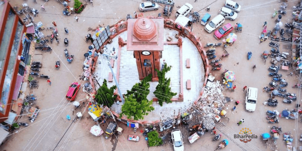
- Darbhanga Tower Chowk: The oldest market place of Darbhanga District, also known as Bada Bazar . You can buy all the household items like, clothes, electronics, mobiles, furniture, groceries, fruits, vegetables, bedding , utensils etc from here. The Huge clocks from kings time, also located on the tower of the chowk.
- Darbhanga Fort (Ram Bagh Fort): Located within the Rambagh campus, it includes temples and the residence of the royal family.
- Temples:
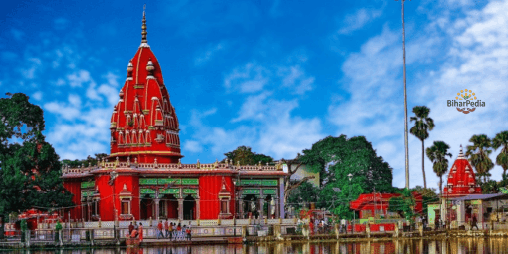
- Shyama Kali Temple (Rameshwari Shyama Mai): Built in 1933 on the funeral pyre of Maharaja Rameshwar Singh, it is a unique site dedicated to Goddess Kali.
- Ahilya Sthan: A temple dedicated to Ahilya, wife of Gautam Rishi, located in Jale block. It hosts fairs during Ramnavami and Vivah Panchami.
- Mahinam-Mahadeo-Sthan: An ancient Shiva temple known for large fairs during Kartik and Maghi Purnima.
- Kankali Temple: Located near Darbhanga railway station, dedicated to Goddess Shakti.
- Maa Tara Temple: A historic temple recently restored by the Darbhanga Raj family.
- Museums:
- Chandradhari Museum: Established in 1957, it houses artifacts, historical items, and Mithila paintings. It was relocated to its current site in 1974 and named after Babu Chandradhari Singh.
- Maharaja Laxmeshwar Singh Museum: Located in the Darbhanga Raj complex, it showcases archaeological and handicraft exhibits.
- Darbhanga Planetarium: Bihar’s second planetarium and science museum, also known as Taramandal, located at Kadirabad Polytechnic Ground in Darbhanga. It was established to promote scientific awareness and education, especially in the fields of astronomy and space science.
- Natural Attractions:
- Other Sites:
Infrastructure
Darbhanga is well-connected and has seen significant infrastructural development.
- Transportation:
- Air: Darbhanga Airport, 6 km from the city center, connects to major cities like Delhi, Mumbai, Bangalore, Hyderabad, and Kolkata via IndiGo and SpiceJet. It is a success story under the UDAN scheme, with 5.75 lakh passengers in nine months during the COVID-19 period.
- Rail: Darbhanga Junction is a major railway station on the East-West Corridor, with direct trains to Delhi, Mumbai, Kolkata, Chennai, Bangalore, and other cities. Travel time from Delhi is 21–24 hours.
- Road: The city lies on NH-57 and NH-105, part of the East-West Corridor connecting Gujarat to Assam. Buses connect Darbhanga to Patna (4 hours), Muzaffarpur (1.5 hours), Siliguri, and Ranchi. Local transport includes cycle rickshaws and shared three-wheelers.
- Metro: A 18.8-km Darbhanga Metro line with 18 stations is planned for completion by 2029.
- Digital Infrastructure:
- The official Darbhanga district website (http://darbhanga.nic.in) uses the S3WaaS platform for accessible government services. It provides updates on tenders, elections, and public grievances.
- The National Informatics Centre (NIC) Darbhanga supports initiatives like the Integrated Road Accident Database (iRAD), vehicle registration (Vahan/Sarathi), and court record digitization.
- Healthcare:
- In addition to Darbhanga Medical College and Hospital, the upcoming AIIMS Darbhanga will bolster healthcare services.
Education and Institutions
Darbhanga is a major educational hub, continuing its Mithila legacy of scholarship. Lalit Narayan Mithila University and Kameshwar Singh Darbhanga Sanskrit University, housed in former palaces, lead in arts and Sanskrit studies. Darbhanga Medical College and Hospital is a key healthcare institute, with AIIMS Darbhanga under construction. Technical education includes Darbhanga College of Engineering, aligning with our prior discussions on Bihar’s technical institutes. Notable alumni include poet Vidyapati and physicist H. C. Verma. The district’s 56.56% literacy rate (2011) reflects progress, though gender gaps persist (male: 66.83%, female: 45.24%).
Statistical Data
Darbhanga District, with a geographical area of 2,279 sq km, has a population of 3,937,385 (2011 Census), ranking 64th in India. Its population density is 1,721 per sq km, with a 19% growth rate (2001–2011). The literacy rate is 56.56% (male: 66.83%, female: 45.24%), and the sex ratio is 911 females per 1,000 males. Urban areas house 9.74% of residents, with Darbhanga city at 380,125 (2021). Scheduled Castes and Tribes comprise 15.64% and 0.07%, respectively.