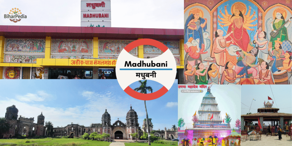
Madhubani, Bihar: The Land of Mithila Art
Madhubani, with its headquarters in Madhubani town, is a culturally vibrant district in Darbhanga Division, renowned for Madhubani painting, a globally celebrated folk art form originating in the Mithila region. Situated along the Kamla-Balan River and bordering Nepal, Madhubani is a hub of agriculture, handloom weaving, and spiritual heritage, with sites like Ugana Mahadev and Kapileshwar Sthan. Known for its rich Mithila traditions, the district is governed by the Madhubani Municipal Council, blending ancient culture with modern aspirations.
Basic Details:
- Location: Madhubani district is situated in northern Bihar, bordering Nepal, between 26.10°–26.67°N latitude and 85.67°–86.50°E longitude, at an average elevation of 55 meters (180 feet). It lies in the fertile Gangetic plains, part of the historic Mithila region.
- Administrative Status: Madhubani is the headquarters of Madhubani district and part of the Darbhanga division, which includes Darbhanga, Samastipur, and Begusarai. Madhubani town is a municipal council, serving as the district’s administrative and cultural hub.
- Population: As provided, the district’s population is 44,87,397 (2011 census), with Madhubani town at ~75,736 (urban). The density is 1,282 persons/km², indicating significant population pressure.
- Area: The district spans 3,501 sq. km, one of Bihar’s larger districts, encompassing urban, rural, and agricultural areas.
- Nickname: Madhubani is known as the “Heart of Mithila” for its cultural heritage and the “Capital of Madhubani Painting” for its globally celebrated art form.
1. Formation and History
- Formation:
- Madhubani district was carved out from the erstwhile Darbhanga district in 1972 to enhance administrative efficiency and promote development in the Mithila region. This bifurcation was part of Bihar’s 1970s reorganization to create smaller, manageable districts.
- The district’s name derives from “Madhuban” (honey forest), reflecting its lush, fertile landscape and cultural sweetness.
- Historical Significance:
- Ancient Period:
- Madhubani is part of the ancient Mithila region, a cradle of Maithili culture, language, and Vedic scholarship. It is mentioned in the Ramayana as the kingdom of King Janak, father of Sita.
- The region was a center of learning, with scholars like Gargi and Yajnavalkya contributing to Upanishadic philosophy. Mithila’s rulers, including the Janakas, fostered art and spirituality.
- Madhubani painting, originating over 2,500 years ago, began as wall art during Sita’s wedding, evolving into a globally recognized folk art.
- Medieval Period:
- Mithila flourished under the Karnata dynasty and later the Oiniwar dynasty, with rulers patronizing Maithili literature and art. The poet Vidyapati (14th century) enriched Maithili culture.
- The region faced invasions but maintained its cultural identity under Mughal and Rajput influence.
- Colonial Period:
- Under British rule, Madhubani was part of the Darbhanga Raj, a princely estate. The British exploited its agricultural wealth, leading to peasant movements.
- Madhubani painting gained recognition in the 1930s when British officer William Archer documented it during famine relief, bringing it to global attention.
- Modern Era:
- Post-independence, Madhubani painting was commercialized, empowering women artists and earning a GI tag in 2007.
- The district remains a cultural hub, with festivals, temples, and art workshops attracting tourists and scholars.
- Madhubani’s proximity to Nepal fosters cross-border cultural and trade ties, with Maithili communities on both sides.
- Ancient Period:
2. Administrative Structure
- Madhubani District
- Madhubani District, one of Bihar’s 38 districts, spans 3,501 sq km and is part of Darbhanga Division, alongside Darbhanga, Samastipur, and others. It comprises 5 sub-divisions (Madhubani Sadar, Benipatti, Jhanjharpur, Phulparas, Jaynagar), 21 blocks, 399 panchayats, and 1,111 villages. A District Magistrate oversees administration, supported by SDMs and BDOs. In 2006, it was listed among India’s 250 most backward districts, receiving Backward Regions Grant Fund support.
- Urban Governance
- The Madhubani Municipal Council, upgraded to a Municipal Corporation in 2018, governs 133,436 residents (2011) across 30 wards. Led by a Mayor and CEO, it manages urban planning, sanitation, and infrastructure, funded by taxes and grants. Reservations include 50% seats for women and 20% for backward classes, per the Bihar Municipal Act of 2007.
3. Location and Geography
- Geographical Boundaries:
- North: Nepal (Sunsari and Morang districts).
- East: Supaul district.
- South: Saharsa and Darbhanga districts.
- West: Sitamarhi district.
- Madhubani’s location, 30 km northeast of Darbhanga and 150 km from Patna, makes it a key cultural and economic center in north Bihar.
- Rivers:
- Kamla-Balan: The district’s most important river, supporting agriculture and pisciculture but causing floods during monsoons due to its proximity to Nepal’s catchment areas.
- Other rivers include Kosi, Bhutahi Balan, and Dhaus, contributing to fertile plains but posing flood risks.
- Topography and Climate:
- Spanning 3,501 sq. km, Madhubani features flat, alluvial Gangetic plains, ideal for agriculture, with no significant hills. Wetlands and ponds support pisciculture.
- Climate: Humid subtropical (Cwa).
- Summer (March–June): Hot and humid, 28–42°C.
- Monsoon (July–September): Heavy rainfall (~1,500 mm annually), with severe flooding risks from Kamla-Balan and Kosi.
- Winter (November–February): Cool, 8–25°C, ideal for tourism and art festivals.
- Seismic Risk: Located in Seismic Zone IV (high risk), requiring flood- and earthquake-resistant infrastructure.
4. Industries and Agriculture
Madhubani’s economy is driven by agriculture, traditional art, and small-scale industries, with a growing focus on tourism and pisciculture.
- Industries:
- Sugar Industry: Processes sugarcane, supporting rural employment, with mills in areas like Jhanjharpur.
- Pisciculture: Fish farming in ponds and wetlands, leveraging Kamla-Balan’s water resources, with species like rohu and catla exported to eastern India.
- Handloom Madhubani Painting: A GI-tagged art form, primarily by women, producing intricate paintings on cloth, paper, and canvas. It’s a major economic driver, with cooperatives like Mithila Art Institute promoting global sales.
- Other Industries:
- Handloom weaving (cotton and silk fabrics).
- Agro-processing for rice and fish.
- Small-scale food processing, including makhana (fox nut) and jaggery.
- Recent Developments:
- The Bihar Industrial Area Development Authority (BIADA) supports art-based entrepreneurship, with plans for a Madhubani Painting Export Hub in Madhubani town.
- Government schemes like Udyog Mitra promote pisciculture and sugar industry growth.
- Agriculture:
- Fertile plains support:
- Paddy: The primary crop, widely cultivated due to abundant water.
- Other Crops: Wheat, maize, lentils, sugarcane, makhana, and vegetables.
- Makhana: Madhubani is a leading producer of GI-tagged Mithila makhana, a superfood exported globally.
- Floods from Kamla-Balan and Kosi disrupt farming, mitigated by canal irrigation and flood-resistant crops.
- Agricultural Initiatives: The National Horticulture Mission supports makhana and vegetable farming, with cooperatives aiding farmers.
- Fertile plains support:
5. Tourism
Madhubani is a cultural and spiritual destination, known for its temples, art heritage, and Mithila traditions. The best time to visit is October to March.
- Key Tourist Places:
- Ugana Mahadev (near Madhubani): A revered Shiva temple, popular for its serene setting and annual Shivratri celebrations.
- Kapileshwar Sthan (Madhubani): A historic Shiva temple, a major pilgrimage site during Sawan and Mahashivratri.
- Uchaitha (Bhagwati Temple): Dedicated to Goddess Durga, a significant Shakti Peeth attracting devotees during Navratri.
- Bhawanipur: A cultural village known for Madhubani painting workshops and traditional Maithili architecture.
- Additional Attractions:
- Saurath Sabha (Saurath): A historic site hosting the annual marriage fair, where Maithil Brahmins arrange marriages, showcasing Mithila’s unique traditions.
- Andhratharhi: A village with active Madhubani painting communities, offering artist interactions and live demonstrations.
- Jhanjharpur: Features the Kali Mandir and local markets for Madhubani art and makhana.
- Mithila Museum (Madhubani): Displays Madhubani paintings, Maithili artifacts, and historical relics of the Mithila kingdom.
- Kamla-Balan Riverfront: Offers scenic views and is used for Chhath Puja rituals.
- Ranti Village: A hub for Madhubani painting, recognized by the government for women-led art cooperatives.
- Brahmapur Temple (near Phulparas): A lesser-known Hindu temple with historical significance.
- Nearby Attractions:
- Darbhanga (30 km): Shyama Mai Temple, Darbhanga Fort.
- Sitamarhi (50 km): Janaki Temple, birthplace of Sita.
- Muzaffarpur (80 km): Litchi gardens, Garib Sthan Mandir.
- Patna (150 km): Patna Museum, Golghar.
- Tourism Support: The Madhubani Municipal Council, under the Bihar Municipal Act of 2007, promotes tourism through art festivals, maintenance of sites like Kapileshwar Sthan, and cultural events like the Mithila Art Festival, per the Twelfth Schedule (e.g., cultural promotion and urban planning).
6. Important Statistical Data
- Area: 3,501 sq. km, one of Bihar’s larger districts, supporting agriculture and rural settlements.
- Headquarters: Madhubani, the cultural and administrative hub.
- Population: 44,87,397 (2011), comparable to countries like Croatia or U.S. states like Kentucky.
- Urban population: ~5% (Madhubani town: 75,736).
- Growth rate (2001–2011): 25.19%.
- Density: 1,282 persons/km², high due to fertile agricultural land.
- Literacy Rate: 58.62% (male: 69.12%, female: 47.36%), below the national average, with a significant gender gap.
- Sex Ratio: 926 females/1,000 males, relatively balanced but reflecting regional gender challenges.
Additional Data:
- Scheduled Castes: 13.54%.
- Scheduled Tribes: 0.03%.
- Languages: Maithili, Hindi, Urdu.
- Urban Bodies: Madhubani Municipal Council (36 wards, with 50% reservations for women, SC/ST, OBC) and nagar panchayats like Jhanjharpur and Ghoghardiha, per the Bihar Municipal Act of 2007.
7. Culture and Society
- Language: Maithili is the dominant language, a recognized Scheduled Language, with Hindi and Urdu also spoken. Madhubani’s literary tradition includes Vidyapati’s poetry and Maithili folk songs.
- Art and Craft:
- Madhubani Painting: A GI-tagged art form with styles like Bharni, Kachni, and Tantrik, depicting mythology, nature, and social themes. It’s UNESCO-recognized as intangible cultural heritage.
- Handloom weaving: Produces Maithili sarees and fabrics.
- Pottery and bamboo crafts, sold in local markets.
- Festivals:
- Mithila Madhyamiki Parv: Celebrates Maithili culture with art, music, and dance.
- Chhath Puja: Widely observed along Kamla-Balan riverbanks.
- Sama-Chakeva: A unique Mithila festival celebrating sibling bonds with clay bird figures.
- Diwali, Holi, Durga Puja, Shivratri, Eid.
- Cuisine:
- Maithili staples: badi-bhat (lentil dumplings with rice), thekua, sattu paratha, makhana kheer.
- Sweets: khaja, peda, balushahi.
- Fish-based dishes, reflecting pisciculture’s prominence.
- Social Challenges:
- Low female literacy (47.36%) and gender disparities in education and employment.
- Frequent flooding disrupts livelihoods, addressed by flood relief programs.
- The Madhubani Municipal Council focuses on slum improvement, public health, and education, per the Twelfth Schedule.
8. Economy and Infrastructure
- Economic Role:
- Madhubani’s economy is anchored by Madhubani painting, agriculture, and pisciculture.
- Madhubani town and Jhanjharpur are trade hubs, with markets like Station Road and Bazaar Chowk for art, makhana, and fish.
- Cross-border trade with Nepal supports agricultural and art exports.
- Infrastructure:
- Transportation:
- Rail: Madhubani and Jhanjharpur are key stations on the Darbhanga-Jaynagar line, connecting to Patna (4 hours), Delhi (24 hours), and Kolkata (14 hours). The India-Nepal rail link (Jaynagar-Janakpur) enhances cross-border connectivity.
- Road: On NH-27, NH-57, and NH-105, linking to Darbhanga (30 km), Patna (150 km), and Nepal’s Janakpur (40 km). Buses, taxis, and auto-rickshaws are common.
- Air: No local airport; nearest is Darbhanga Airport (35 km) for domestic flights or Patna’s Jay Prakash Narayan International Airport (150 km).
- Local Transport: E-rickshaws and cycle-rickshaws in Madhubani and rural areas.
- Digital Infrastructure: The district website (http://madhubani.nic.in) offers e-governance services like tenders, voter registration, and flood alerts.
- Healthcare: Sadar Hospital Madhubani, Jhanjharpur Government Hospital, and private clinics. Darbhanga’s medical facilities are accessible for advanced care.
- Urban Development: The Madhubani Municipal Council manages urban planning, waste management, and infrastructure, funded by taxes and grants. Madhubani is part of the AMRUT scheme, with projects like water supply and drainage upgrades.
- Transportation:
9. Education
- Universities:
- Ram Krishna College, Madhubani: A prominent institution offering arts, science, and commerce programs.
- Mithila University (Darbhanga, 30 km): Serves Madhubani students with higher education.
- Other Institutions: J.N. College, R.K. College, and schools like Watson High School.
- Cultural Education: The Mithila Art Institute and local NGOs offer Madhubani painting workshops, empowering women and youth.
10. Recent Developments
- Tourism Infrastructure:
- Upgrades to Kapileshwar Sthan and Uchaitha temples, with better facilities for pilgrims, ahead of Durga Puja 2025.
- Promotion of Madhubani painting through art fairs and online platforms like biharpedia.com.
- Industrial Growth:
- Madhubani Painting Export Hub planned to streamline global sales.
- Expansion of pisciculture units with government subsidies.
- Infrastructure:
- India-Nepal Rail Link: Fully operational, boosting tourism and trade.
- AMRUT Projects: Include smart drainage systems to mitigate flooding in Madhubani town.
- Agricultural Advancements:
- Makhana processing units to enhance export value.
- Flood-resistant paddy varieties introduced by the state government.
11. Challenges
- Flooding: Kamla-Balan and Kosi rivers cause severe annual floods, disrupting agriculture and infrastructure.
- Socioeconomic Issues: Low literacy (58.62%), especially among females (47.36%), and rural poverty.
- Art Commercialization: While Madhubani painting empowers artists, middlemen often reduce profits, addressed by cooperatives.
- Urban Congestion: Madhubani town’s growth strains civic amenities, managed by the Municipal Council.