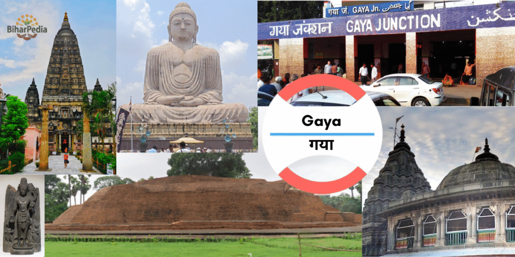
Gaya: The Spiritual and Historical City of Bihar
Gaya is one of the most sacred cities in India, known for its Buddhist, Hindu, and Jain religious significance. on the Phalgu River, is the headquarters of Gaya District and Magadh Division, renowned as the site where Lord Buddha attained enlightenment under the Bodhi Tree in Bodhgaya. A global pilgrimage hub for Buddhists and Hindus, Gaya is steeped in history, with landmarks like the Mahabodhi Temple (a UNESCO World Heritage Site) and vibrant industries such as sugar and textiles. Gaya is also famous for Pind Daan, an important Hindu ritual performed for ancestors. The Gaya Municipal Corporation governs its urban growth, blending spiritual heritage with modern development.
Basic Details:
- Location: Gaya district is situated in southern Bihar, on the banks of the Phalgu River, between 24.29°–25.09°N latitude and 84.35°–85.30°E longitude, at an average elevation of 113 meters (371 feet). It lies in the Gangetic plains, with hilly terrain in the south.
- Administrative Status: Gaya is the headquarters of Gaya district and Gaya division, which includes Aurangabad, Jehanabad, Arwal, and Nawada districts. It is a municipal corporation and one of Bihar’s major urban centers.
- Population: As provided, the district’s population is 43,91,418 (2011 census), with Gaya city at ~468,614 (urban agglomeration). The density is 883 persons/km².
- Area: The district spans 4,976 sq. km, one of Bihar’s larger districts, encompassing urban, rural, and forested areas.
- Nickname: Gaya is known as the “City of Enlightenment” for Bodh Gaya’s Buddhist significance and the “Land of Pind Daan” for Hindu ancestral rituals.
1. Formation and History
- Formation:
- Gaya district came into existence as an independent district in 1865 during British colonial rule, carved out from the larger Behar district for administrative convenience. This restructuring aimed to improve governance, revenue collection, and law enforcement in southern Bihar.
- Post-independence, Gaya was reorganized, with Nawada (1986), Aurangabad (1973), Jehanabad (1986), and Arwal (2001) separated as distinct districts.
- Historical Significance:
- Ancient Period:
- Gaya is part of the ancient Magadha region, a cradle of Indian civilization and the seat of the Maurya and Gupta empire, home to kings like Bimbisara and Ashoka. It was a major center for Buddhism, Jainism, and Hinduism.
- Bodh Gaya, a UNESCO World Heritage Site, is where Siddhartha Gautama attained enlightenment under the Bodhi Tree in the 6th century BCE, becoming the Buddha. The Mahabodhi Temple marks this sacred site.
- The region is mentioned in the Ramayana and Mahabharata, with Gaya city linked to the legend of Gayasura, a demon whose body formed the sacred landscape for pind daan rituals.
- Medieval Period:
- Gaya was under the Pala and Sena dynasties, with Buddhist monasteries flourishing until their decline by the 12th century due to invasions.
- Mughal rulers used Gaya as a regional administrative center, with the Phalgu River facilitating trade.
- Colonial Period:
- Gaya was a key British administrative hub in the Bengal Presidency. The 1857 Rebellion saw local uprisings, and the British developed infrastructure like the Grand Trunk Road.
- The district was a center for indigo and opium trade, with British planters exploiting local farmers, leading to social unrest.
- Modern Era:
- Gaya played a significant role in the independence movement, with leaders like Jayaprakash Narayan, born in nearby Sitab Diara, inspiring nationalist fervor.
- The district has faced challenges like Maoist insurgency in its southern hilly areas but has focused on development through tourism and industry.
- Gaya’s global prominence as a pilgrimage site continues, with Bodh Gaya hosting international Buddhist gatherings.
- Ancient Period:
2. Administrative Structure
- Gaya District
- Gaya District, one of Bihar’s 38 districts, spans 4,976 sq km and is part of Magadh Division, alongside Arwal, Aurangabad, Jehanabad, and Nawada. It comprises 4 sub-divisions (Gaya Sadar, Sherghati, Tekari, Neemchak Bathani), 24 blocks, 287 panchayats, and 2,881 villages. A District Magistrate oversees administration, supported by SDMs and BDOs. In 2006, it was listed among India’s 250 most backward districts, receiving Backward Regions Grant Fund support.
- Urban Governance
- The Gaya Municipal Corporation, established in 1982, governs 347,781 residents (2011) across 45 wards. Led by a Mayor and CEO, it manages urban planning, sanitation, and infrastructure, funded by taxes and grants. Reservations include 50% seats for women and 20% for backward classes, per the Bihar Municipal Act of 2007.
3. Location and Geography
- Geographical Boundaries:
- North: Arwal, Jehanabad, and Nalanda districts.
- East: Nawada district.
- South: Jharkhand (Hazaribagh, Koderma, Chatra districts).
- West: Aurangabad district.
- Gaya’s location, 100 km south of Patna, makes it a gateway to southern Bihar and Jharkhand, with Bodh Gaya as a global pilgrimage hub.
- Rivers:
- Phalgu: The district’s most important river, sacred for Hindu pind daan rituals performed at Vishnupad Temple and other ghats. It is a seasonal river, often dry outside the monsoon due to its sandy bed.
- Other rivers include Morhar, Sone, and Falgu tributaries, supporting agriculture but posing flood risks during monsoons.
- Topography and Climate:
- Spanning 4,976 sq. km, Gaya features flat Gangetic plains in the north and hilly terrain in the south (part of the Chota Nagpur Plateau). Forests cover ~15% of the area, with hills like Pretshila and Ramshila.
- Climate: Humid subtropical (Cwa).
- Summer (March–June): Hot, 28–45°C.
- Monsoon (July–September): ~1,000 mm rainfall, with flood risks.
- Winter (November–February): Cool, 5–25°C, ideal for tourism.
- Seismic Risk: Located in Seismic Zone III (moderate risk).
4. Industries and Agriculture
Gaya’s economy is driven by agriculture, pilgrimage tourism, and a mix of traditional and modern industries.
- Industries:
- Sugar Industry: Processes sugarcane, a major crop, with mills in rural areas.
- Cotton Textile: Small-scale units produce fabrics, complementing local trade.
- Tobacco: Processing units for chewing tobacco and related products.
- Leather Industry: Tanneries and leather goods manufacturing, supporting local markets.
- Lac Industries: Produces lac-based products like bangles and decorative items.
- Oil Mills: Process mustard and other edible oils.
- Other Industries: Include food processing, cement, and small-scale manufacturing. The Bihar Industrial Area Development Authority (BIADA) promotes industrial growth in Gaya.
- Recent Developments: Plans for an Agro-Processing Park and Tourism-Based Industries (e.g., handicrafts for pilgrims) aim to boost the economy, supported by the Gaya Municipal Corporation’s economic development initiatives (Twelfth Schedule).
- Agriculture:
- Fertile plains support:
- Paddy, wheat, sugarcane, corn (as provided): Staple crops.
- Other Crops: Pulses, vegetables, and oilseeds.
- Gaya’s agricultural output is vital for local markets and trade with Jharkhand.
- Challenges: Limited irrigation and monsoon dependence, addressed by schemes like the Bihar Agricultural Development Program.
- Fertile plains support:
5. Tourism
Gaya is a global pilgrimage destination for Buddhists and Hindus, with a rich array of historical, religious, and natural sites. The best time to visit is October to March.
- Key Tourist Places:
- Bodhgaya: A UNESCO World Heritage Site, where Lord Buddha attained enlightenment in the 6th century BCE. Key attractions include:
- Mahabodhi Temple: A 5th-century CE temple, rebuilt over centuries, housing the Bodhi Tree and a diamond throne.
- Bodhi Tree: A descendant of the original tree under which Buddha meditated, a sacred site for Buddhists.
- Archaeological Museum: Displays Buddhist artifacts, sculptures, and relics from the Maurya and Gupta periods.
- Thai Monastery: One of many international monasteries (Chinese, Japanese, Tibetan) reflecting Bodh Gaya’s global appeal.
- Sujata Garh/Village: Marks the site where Sujata offered rice milk to Buddha, ending his asceticism. Features a stupa and archaeological remains.
- Baba Koteshwarnath Temple (Koteshwar): A revered Shiva temple, popular among locals.
- Pretshila Hill: A sacred hill for Hindu pind daan rituals, offering panoramic views and a temple dedicated to ancestral spirits.
- Ramshila Hill: Another hill associated with Hindu rituals, featuring a temple and scenic trails.
- Tekari Fort: A 16th-century fort in Tekari, 35 km from Gaya, reflecting the region’s Rajput and Mughal history.
- Vishnupad Temple (Gaya city): A Hindu pilgrimage site for pind daan, housing a 40 cm footprint of Lord Vishnu on a basalt rock.
- Bodhgaya: A UNESCO World Heritage Site, where Lord Buddha attained enlightenment in the 6th century BCE. Key attractions include:
- Additional Attractions:
- Dungeshwari Caves (Mahakala Caves, 12 km from Bodh Gaya): Where Buddha meditated before enlightenment.
- Barabar Caves (40 km from Gaya): Ancient rock-cut caves from the Maurya period (3rd century BCE), India’s oldest surviving rock-cut architecture.
- Brahmayoni Hill: A trekking spot with a temple, linked to Hindu mythology.
- Gaya Museum: Showcases regional artifacts, including Buddhist and Hindu relics.
- Falgu River Ghats: Sites like Devghat and Suryakund are used for pind daan and religious ceremonies.
- Nearby Attractions:
- Rajgir (70 km): A Buddhist and Jain pilgrimage site with hot springs and ancient ruins.
- Nalanda (80 km): A UNESCO site with the ruins of the ancient Nalanda University.
- Pawapuri (90 km): Where Lord Mahavir attained nirvana.
- Kakolat Waterfall (Nawada, 60 km): A scenic natural site.
- Tourism Support: The Gaya Municipal Corporation, under the Bihar Municipal Act of 2007, promotes tourism through urban beautification, maintenance of sites like public parks, and cultural events, per the Twelfth Schedule (e.g., cultural promotion and urban planning).
6. Important Statistical Data
- Area: 4,976 sq. km, one of Bihar’s larger districts, encompassing plains, hills, and forests.
- Headquarters: Gaya, the administrative and spiritual hub.
- Population: 43,91,418 (2011), comparable to countries like Colombia or U.S. states like Virginia.
- Urban population: ~13% (city: 468,614).
- Growth rate (2001–2011): 26.09%.
- Density: 883 persons/km², moderate compared to urbanized districts.
- Literacy Rate: 63.67% (male: 73.31%, female: 53.34%), below national average, with a gender gap.
- Sex Ratio: 937 females/1,000 males, relatively balanced but below national norms.
Additional Data:
- Scheduled Castes: 28.67%, one of the highest in Bihar.
- Scheduled Tribes: 0.08%.
- Languages: Hindi, Magahi, Urdu.
- Urban Bodies: Gaya Municipal Corporation (53 wards, with 50% reservations for women, SC/ST, OBC) and nagar panchayats like Bodh Gaya and Sherghati, per the Bihar Municipal Act of 2007.
7. Culture and Society
- Language: Hindi and Magahi dominate, with Urdu spoken by the Muslim community. Gaya’s literary tradition includes folk songs and devotional literature.
- Art and Craft:
- Lac Bangles and Stone Carvings: Popular handicrafts sold to pilgrims.
- Buddhist-inspired art, including thangkas and statues, thrives in Bodh Gaya.
- Festivals:
- Buddha Purnima: Celebrates Buddha’s birth, enlightenment, and death, with global pilgrims in Bodh Gaya.
- Pitru Paksha Mela: A 16-day Hindu festival for pind daan, drawing millions to Gaya’s ghats.
- Chhath Puja, Diwali, Holi, Eid.
- Cuisine:
- Bihari staples: litti-chokha, sattu paratha, khichdi.
- Sweets: tilkut, anarsa, khaja.
- Vegetarian food dominates in Bodh Gaya due to Buddhist influence, with international cuisines available.
- Social Challenges:
- Low female literacy (53.34%) and socioeconomic disparities.
- Maoist insurgency in southern hills, though declining due to security measures.
- The Gaya Municipal Corporation addresses slum improvement, public health, and education (Twelfth Schedule).
8. Economy and Infrastructure
- Economic Role:
- Gaya’s economy is anchored by pilgrimage tourism, agriculture, and small-scale industries.
- Markets like G.B. Road and Tekari Road cater to pilgrims and locals.
- Infrastructure:
- Transportation:
- Air: Gaya International Airport, 12 km from Bodh Gaya, connects to Delhi, Kolkata, and international destinations like Bangkok, Colombo, and Paro (Bhutan), serving pilgrims.
- Rail: Gaya Junction is a major station on the Howrah-Delhi main line, with trains to Patna (2 hours), Delhi (12 hours), and Kolkata (8 hours).
- Road: On NH-19, NH-22, and NH-83, linking to Patna (100 km), Ranchi (170 km), and Varanasi (250 km). Buses, taxis, and auto-rickshaws are common.
- Local Transport: E-rickshaws and shared autos in Gaya and Bodh Gaya.
- Digital Infrastructure: The district website (http://gaya.nic.in) offers e-governance services like tenders, voter services, and case tracking.
- Healthcare: Anugrah Narayan Magadh Medical College and Hospital (ANMMCH) and private facilities. An AIIMS-like institute is under consideration.
- Urban Development: The Gaya Municipal Corporation manages urban planning, waste management, and infrastructure, funded by taxes and grants. Gaya is part of the Smart Cities Mission, with projects like smart roads and riverfront development.
- Transportation:
9. Education
- Universities:
- Magadh University (Bodh Gaya): A major institution offering diverse programs.
- Central University of South Bihar (Gaya): Focuses on research and higher education.
- Medical Institutions: ANMMCH, a leading medical college.
- Other Colleges: Gaya College, Mirza Ghalib College.
- Coaching Hub: Known for UPSC, medical, and engineering exam preparation, especially for students from rural areas.
10. Recent Developments
- Tourism Infrastructure:
- Upgrades to Bodh Gaya’s facilities, including better roads and international tourist amenities, ahead of Buddha Purnima 2025.
- Mahabodhi Temple conservation efforts by the Archaeological Survey of India.
- Industrial Growth:
- Plans for an Agro-Processing Park to process sugarcane and corn.
- Handicraft Clusters for lac and stone crafts.
- Infrastructure:
- Gaya Airport Expansion: To handle more international flights.
- Smart City Projects: Include CCTV surveillance and Phalgu riverfront beautification.
- Environmental Efforts:
- Afforestation in southern hills to combat soil erosion.
- Phalgu River cleanup initiatives by the Municipal Corporation.